A month that went beyond grim - record rainfall, temperatures and wind and of course, storm 'Desmond'.
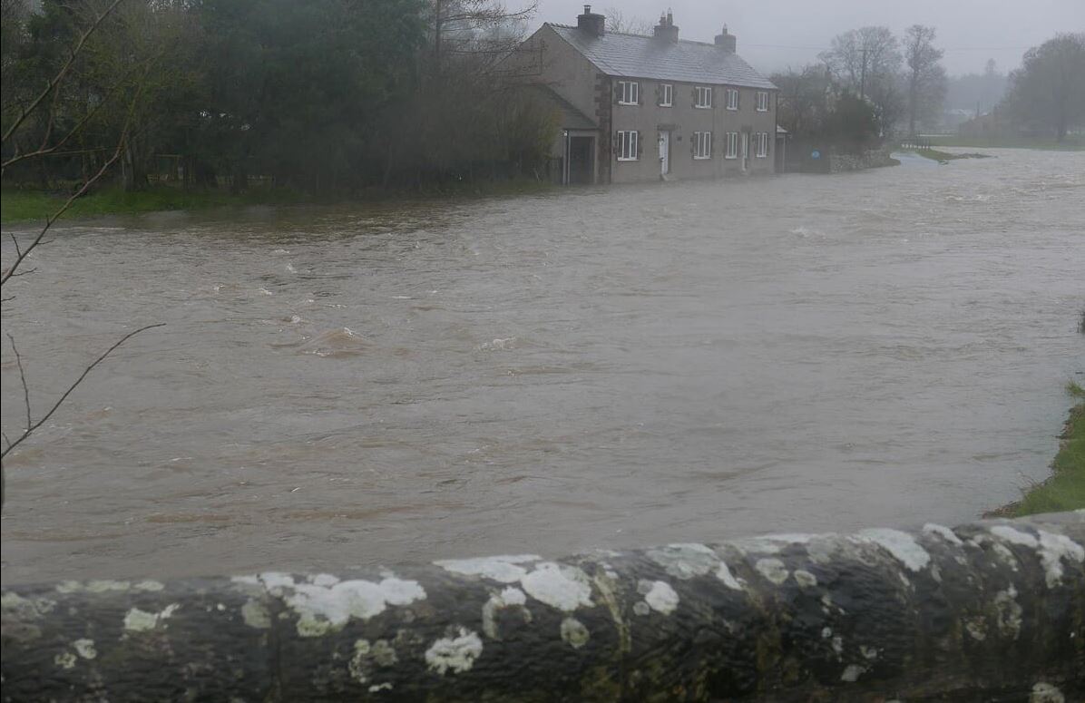
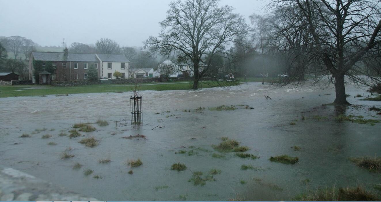
The floods, in the morning before it got bad!! all photo's courtesy of Helen Marsh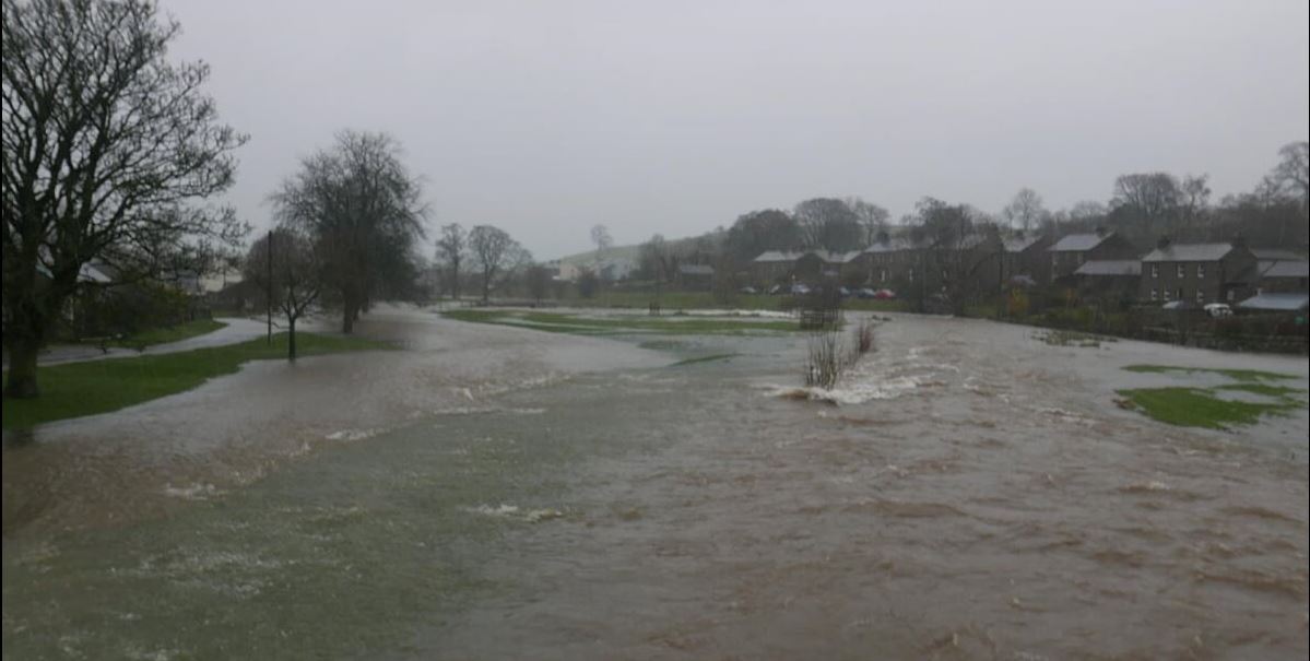
A month that went beyond grim - record rainfall, temperatures and wind and of course, storm 'Desmond'.
The floods, in the morning before it got bad!! all photo's courtesy of Helen Marsh
December went beyond grim, a month that put its foot on your throat, pressed down hard, then a little harder and never had the decency to release the pressure even slightly, let alone take its foot from off your throat. Its impacts went beyond a 'weather event' and became a 'human story', one that simply will not be forgotten. A simply tiring and exhausting month.
The month was record breaking for all the wrong reasons, but for the record they are: the wettest of any month, the wettest 24hr (341.4 mm at Honister) and 48hr periods (405.0 mm at Thirlmere) (beating the records set in November 2009 and which were generally considered to be virtually impregnable).
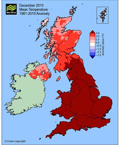
It was also the warmest December on record, Newton Rigg at 7.6°c far surpassing the 6.84°c of 1934 and which is some 4.2°c above the December average. Here at Maulds Meaburn 20 days attained at least 10°c! And it was also the windiest, a mean wind speed of 12.9 mph here at Maulds Meaburn beat the previous high of 12.0 mph and the daily mean wind speed of 32.0 mph for the 24hrs of the 5th was, along with the rainfall, crazily high.
MSLP of 1010.5 Mb was -1.6 Mb below the local average for December with the month experiencing a strong Jet Stream with a very mobile and dynamic south-southwesterly flow that was full of warm, moist air that was frequently of a tropical origin. This resulted in numerous and frequent weather systems arriving from off the Atlantic and with high pressure anchored over Europe for virtually the entire month, those systems tended to follow the same path, from the mid Atlantic tracking north to Iceland. The associated frontal systems occasionally became static or slow moving over the north of England, resulting in the high daily rainfall totals with eight days recording in excess of an inch (25.4 mm) of rain. December now accounts for three of my top ten wettest days, obviously the 5th is the wettest of them all, the others being: the 4th (3rd wettest) and the 21st (9th).
Overall a mean minimum of 4.52°c and a mean maximum of 10.27°c saw the temperature 4.0°c above the 1981-2010 average, making it the warmest December on record, beating the record held since 1934. The highest maximum temperature recorded was 14.1°c (18th), the lowest minimum -3.2°c (13th).
Rainfall of 571.9 mm (Crosby Ravensworth School 676.0 mm) made it the wettest of any month on record and here at Maulds Meaburn was 398% of the December average for 2007-14. Locally rainfall was typically 325-360% of average.
At the Met' Office site at Newton Rigg, 329.4 mm (313.7 %) not only made it the wettest December in a series back to 1900 but also the wettest of any month on record, beating the 269.4 mm of November 2009. A mean temperature of 7.6°c is also the warmest on record for December in a series back to 1914.
Figures from the Environment Agency�s rainfall sites were, (figure in brackets being the monthly average for 1961-90) �Data kindly provided by the Hydrometry and Telemetry team of the Environment Agency (Penrith)�:
Kirkby Thore 260.0 mm (71.7 mm)
Brothers Water 1058.2 mm (304 mm)
Nunwick Hall 255.4 mm (78.3 mm) and
966.6 mm at Seathwaite Farm (Borrowdale - 382 mm [average for 1981-2010])
1st - 3rd Appropriately the month started unsettled. A warm front pushed north over the UK from the south, introducing milder air and which was followed by low pressure (LP) near Iceland pushing a series of frontal systems across the UK on the 2nd and 3rd.
Rain on the 3rd, 30.8 mm, became very heavy during the afternoon and evening with a warm front becoming semi-static over the UK. This heavy rain, coupled with the wet November created the ground conditions that would perpetuate what was about to happen.
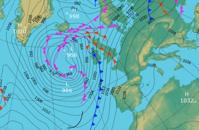
4th - 6th 'Desmond' The fourth named storm of the season and one that shall not be forgotten, no matter how hard you might try!
Firstly, some context should be set. This event has been likened to the events of November 2009, which was the wettest month of any month in the local records and also included the wettest ever day along with the wettest periods of 48, 72 and 96 hrs. Whilst the 2009 event was wet and stormy in the east of Cumbria, it paled into insignificance to what occurred further west. However, Desmond affected a much wider area and it impacts were greater because of this.
In November 2009 the rains occurred over the 18-20th with the focus on the 19th when 45.8 mm was recorded here at Maulds Meaburn (the total rainfall for the 18-20th being 82.6 mm) and which wasn't even the wettest day of 2009 and even now is only the 8th wettest day in my records! - below we will see how that compares with Desmond. Previously to Desmond the wettest day in my records was when 68.0 mm fell on 10th January 2009 (100 mm at Shap, which was also wetter on the 19th October than the 19th November).
My records started in June 2007, so I missed the floods of 7th January 2005, the last time that Maulds Meaburn flooded. On that day Shap recorded 118.6 mm, which was its wettest day of the year.
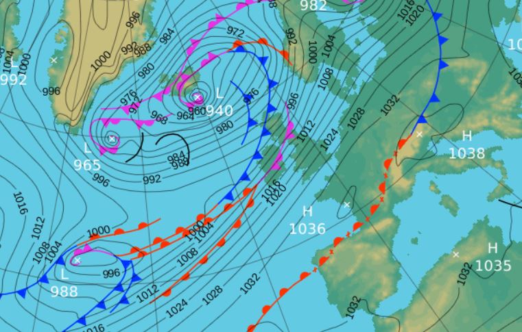
So what was Desmond? It was a slow moving depression, with a centre of 940 Mb that didn't actually get that close to the UK, the centre tracking east of Iceland. However, it had a frontal system trailing from it that dissected the northern portion of England and trailed away into the mid Atlantic. But most crucially it had a strong feed of warm and moist tropical air and partly due to the dominance of high pressure (HP) over Europe, those fronts stalled once over the UK - the outcome being the prodigious rainfall totals across Cumbria.
The rain arrived during the evening of the 4th and from 2030 hrs that night to 0215 hrs on the 6th there was not a single 5 minute period that did not record at least 0.2 mm of rain, virtually 30 hrs of non-stop heavy rain and with a little bit more either side of those 30 hrs.
The rainfall totals were (these are the 24hr periods of 09-0900 hrs): Maulds Meaburn 4th = 63.8 mm 5th = 122.4 mm quite easily the wettest day in my records and the 4th is also the third wettest day. Along with the 30.8 mm on the 3rd this is also the first time that this site has recorded in excess of 1" of rain on three consecutive days.
The 48 hrs rainfall for the 4-6th at Shap (Met' Office) was 262.6 mm and Crosby Ravensworth School was not that far behind at 229.6 mm (which again for just the 0.7 miles difference to Maulds Meaburn is some margin).
And of course the rain wasn't the only story of the day has we also encountered gale force winds. The year's highest gust of wind, 69 Mph actually introduced Desmond to us in the early evening on the 4th and then it wasn't until the morning of the 6th when the winds started to abate. In that time the 5th, on top of the rain, had a mean wind speed of 32.0 mph (a new record), that is 'near gale' force winds for the entire day.
Gales (a 10 minute mean wind speed of 39 mph) were recorded twice, at 0200 hrs on the 5th and then, surprisingly, not again until 0640 hrs on the 6th. In that time, apart from the 69 mph gust on the 4th, the 5th was never far away from its next 50 mph gust, with the highest being 62 mph and the 6th saw a highest gust of 61 mph during its gale in the morning.
So, it left the village with several house flooded, effectively cut-off during the Saturday and one footbridge destroyed during an unforgettable 36 hours and obviously all our thoughts and best wishes go to those who properties were flooded.
But one footnote to this is the rapid decrease in the daily rainfall totals as we move north of Maulds Meaburn. Both Kirkby Thore and Nunwick Hall recorded 44.2 mm on the 5th and it was only 49.0 mm at Newton Rigg. In the 6 miles between Maulds Meaburn and Kirkby Thore the rainfall rate dropped off at 13.0 mm per mile, quite extraordinary.
7th - 11th And it remained unsettled with a new area of LP bringing 18.4 mm of rain late evening 7th and overnight into the 8th. Then yet another LP system on the 9th followed a similar track to those earlier systems and gave yet another 30.8 mm, with a particularly heavy spell of rain in the evening - it was this rain that caused the second round of flooding in Glenridding.
In the feed of warm southerly air the 7th had attained a high temperature of 13.1°c (55.6°f) a new, but short lived, high temperature record for December and indeed the first seven days of the month had all seen the mercury rise above 10°c, quite phenomenal for this time of year.
The 10-11th both saw a little rain but were generally quieter days with the temperature falling back, but still above average.
12th - 13th We then had a very brief wintry weekend - cold air was sat over northern England and Scotland and as fronts connected to LP over Anglesey slowly moved north and collided with that cold air, rain soon turned to snow.
From several hours through mid morning to just after 1600 Hrs, snow fell continuously, leaving a good covering that iced over during the night as temperatures fell to a month's low of -3.2°c (26.2°f); we had our one day of lying snow for the month. The 12th was also cold with the temperature dropping as the day progressed, however, the month's coldest day, 2.5°c (36.5°f) was claimed by the 13th which started sunny, but soon clouded over with light rain in the afternoon as the fronts from the previous day once again pushed north.
Cold snap over and now it was back to the wet and crazily mild.
14th - 22nd (Spring temperatures) Whilst the grim weather returned, becoming progressively wetter during the period, the theme was one of just how mild it became with temperatures more akin to late spring.
A strong south-southwesterly flow developed from the 15th and whilst there was rain every day, until the 18th it was only light. But with each day the temperature rose, culminating in 14.1°c (57.4°f) on the 18th, crazily high for December and a new record at various sites across Cumbria, including this one. It was also mild by night with minima on both the 17-18th topping 10°c, the 10.5°c to start the 17th was yet another new record for December.
The 18th then saw a return to heavier rainfall as a deep area of LP in the mid Atlantic steadily tracked north to Iceland with its associated frontal systems spiralling off the LP responsible for that rain. 14.3 mm on the 18th was followed by 35.8 mm on Saturday 19th with rain that became increasingly heavy during the afternoon, with yet more falling overnight into the 20th. Desmond, then snow, then back to heavy rain, Saturdays in December were proving to be a day to avoid!
The 20th saw something slightly fresher as the wind began to turn west-southwesterly and which was a day of frequent and heavy showers. One such shower in the morning gave a quite violent 20 minute spell of hail.
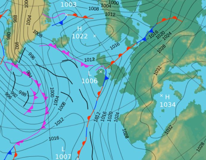
 Midnight 18-19th - Shows the feed of southerly winds that brought the abnormally high temperatures
After the fresher feel of the 20th, the next 21st-22nd saw a return to mild conditions ... and heavy rain! A new area of LP overnight repeated the theme of what had gone before, strong, moist south-westerly flow and the result was a spell of very heavy rain overnight into the 22nd, 45.7 mm being credited back to the 21st. The rain steadily petered out during the morning.
23rd - 24th It was a little quieter in the run up to Christmas, the temperature dipping, although remaining well above average for December. Christmas Eve saw a hail shower at 1745 Hrs followed by further sleet showers during the night and in the early hours of Christmas day.
25th - 31st Through to the end of the month it once again turned grim. The next area of LP arrived Christmas Day afternoon, this one tracking closer to the UK through Eire and which caused further flooding, but more so in Yorkshire in Lancashire. The LP was slow moving and once again became stalled over the northern half of the UK, but the main thrust of the rain stayed further south than predicted and hence Cumbria despite the high rainfall totals, avoided the worst. Christmas Day saw 31.4 mm and then Boxing Day a further 40.6 mm, another occasion with over an inch of rain on consecutive days.
 25-26th - Looks innocuous, but having stalled deposited high rainfall totals
The 27th was a better day as we sat in a slack pressure gradient, staying dry during the day with a little weak sunshine and the 28th again saw us clear of fronts in daylight hours. It was terribly mild though in the southerly flow. After the blip in temperatures on the 24th, every day had attained at least 11° with both the 28-29th topping 12°.
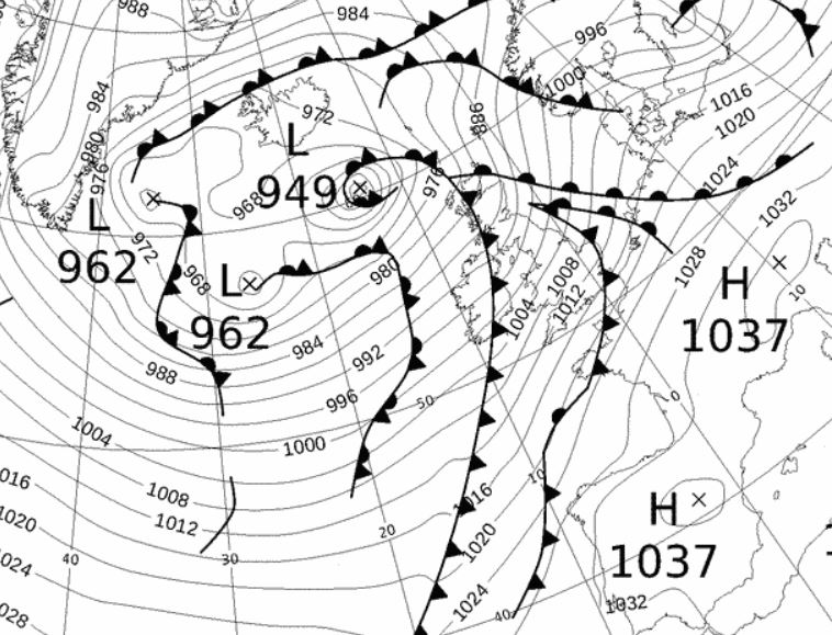
Storm 'Frank' on the 29-30th looked impressive on the charts, but most fortuitously the main centre, which fell to 929 Mb, avoided us, staying out to our west, giving some terrible conditions in Eire. However, the wind and rain (14.4 mm) lasted for most of the day and the year ended on a fresher note, although still wet, with the temperature dipping to 6.0°c.
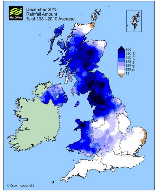
Rainfall totalled 571.9 mm for the month, with rain recorded on 31 days of which 28 were 'Wet days' (1.0mm +).
The Mean Temperature for the month was 7.39°c -- The Mean Max' was 10.27°c -- The Mean Min' 4.52°c.
We had 3 Air Frosts in the month (year 49) -- Grass frosts totalled 12 (year 120).
The 1 foot soil temp ranged from a low of 4.6°c on the 14th to a high of 9.1°c on the 20th -- with a monthly mean of 7.1°c
The 1 meter soil temp ranged from a low of 7.7°c on the 16th to a high of 8.5°c on the 1st, 8-12th and 21st-23rd -- with a monthly mean of 8.2°c
COMPARISONS:-
* December 2015 rainfall was 398% of the December average for 2007 - 2014
* December 2015 was 4.48°c warmer than the December average for 2009 - 2014 and 4.0°c warmer than the local long term average 1981-2010
* 2014 TEMP 9.58°c -- RAIN 1343.8 mm
* 2013 TEMP' 8.49°c -- RAIN 1232.1 mm
* 2012 TEMP' 8.26°c -- RAIN 1415.9 mm
* 2011 TEMP' 9.17°c -- RAIN 1305.4 mm
* 2010 TEMP' 7.42°c -- RAIN 702.9 mm
* 2009 TEMP' 8.86°c -- RAIN 1264.5 mm
* 2008 TEMP' -- RAIN 1381.3 mm
This makes the year 2015 0.12°c warmer than the average for 2009-14 and with 134.7% of rainfall for 2008-14
JANUARY 2010
FEBRUARY 2010
MARCH 2010
APRIL 2010
MAY 2010
JUNE 2010
JULY 2010
AUGUST 2010
SEPTEMBER 2010
OCTOBER 2010
NOVEMBER 2010
DECEMBER 2010
JANUARY 2011
FEBRUARY 2011
MARCH 2011
APRIL 2011
MAY 2011
JUNE 2011
JULY 2011
AUGUST 2011
SEPTEMBER 2011
OCTOBER 2011
NOVEMBER 2011
DECEMBER 2011
JANUARY 2012
FEBRUARY 2012
MARCH 2012
APRIL 2012
MAY 2012
JUNE 2012
JULY 2012
AUGUST 2012
SEPTEMBER 2012
OCTOBER 2012
NOVEMBER 2012
DECEMBER 2012
SUMMER 2012
REVIEW OF 2012
JANUARY 2013
FEBRUARY 2013
MARCH 2013
APRIL 2013
MAY 2013
JUNE 2013
JULY 2013
AUGUST 2013
SEPTEMBER 2013
OCTOBER 2013
NOVEMBER 2013
DECEMBER 2013
REVIEW OF 2013
JANUARY 2014
FEBRUARY 2014
MARCH 2014
APRIL 2014
MAY 2014
JUNE 2014
JULY 2014
AUGUST 2014
SEPTEMBER 2014
OCTOBER 2014
NOVEMBER 2014
DECEMBER 2014
WINTER 2014
REVIEW OF 2014
JANUARY 2015
FEBRUARY 2015
MARCH 2015
APRIL 2015
MAY 2015
JUNE 2015
JULY 2015
AUGUST 2015
SEPTEMBER 2015
OCTOBER 2015
NOVEMBER 2015
REVIEW OF 2015
© Darren Rogers 2015
Want to comment on this site? email